COOMBE BISSETT & HOMINGTON
  • Home
  • Parish Council
    • Minutes
    • Agenda for Next Meeting
    • Parish Council Policies
    • Financial Data
    • Contact Your Councillors
    • Flood Alert!
    • Parish Council History
  • Neighbourhood Plan
    • Consultation
    • EVIDENCE BASE
    • Minutes of Meetings
    • Contact
  • LATEST FLOOD WARNING
  • FLOOD INFORMATION
  • Village Calendar
  • CB&H FTTP Project
  • Speed Indicator Device (SID)
    • Salisbury Road
    • Blandford Road
    • Stratford Tony Road
    • Tottens Farm
    • Homington Village
  • Coronavirus Support
  • CB & H Express
    • Adverts
  • Fox & Goose
  • Coombe Bissett Stores
  • Village Halls
    • Coombe Bissett
    • Bishopstone
  • Churches
    • Coombe Bissett
    • Homington
    • Coffee Mornings-Wed
    • Chalke Valley Churches
  • Clubs
    • Badminton
    • Bellringing
    • Bowling
    • Cricket
    • Drama
    • Short Mat Bowling
    • Tennis
  • Coombe Bissett Down
    • Wiltshire Wildlife Trust
    • Friends of Coombe Bissett Down
    • CB Down Facebook Page
  • Loneliness
  • Government
    • Our M.P.
    • Salisbury City Council
    • Wiltshire Council
    • Planning
    • Village Statistics
    • Household Emergencies
  • History
    • Coombe Bissett
    • Homington
    • Photo Archive >
      • Old Photographs (1)
      • Old Photographs (2)
      • Flooding Feb 1990
      • Floods 2014
      • Floods 2015
    • Church Memorials
    • WW1 Servicemen
  • School
  • Services
    • Salisbury Hospital >
      • Hospital Website
      • Trust Membership
    • Tradesmen
    • Link Transport
    • Refuse Collection
    • Buses
  • Village Cinema
  • Village Show
  • Maps & Walks
    • Local Walks >
      • Rights of Way
    • Footpath Map
    • Walk to Salisbury
    • Google Maps
  • Home
  • Jubilee

Walking to Salisbury


I decided recently, after forty years in the village, that I ought to try walking to Salisbury. So I did.

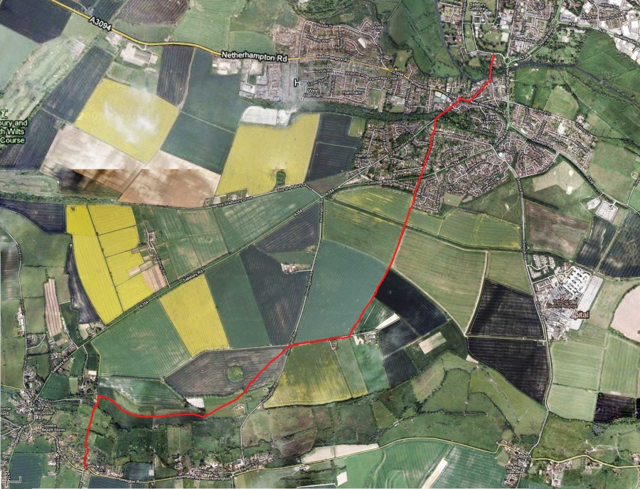
My route from Coombe Bissett went down Stocksbridge Lane, and over the Ebble ford. The track led to a gate into the water meadows, on the far side of which is another gate over the stream that drains the old watercress beds. Then another hundred yards up the slope to level with the gardener’s cottage to Homington House.

There, one turns sharp right and the footpath skirts the bottom of the steeper slope of the down After a couple of very functional galvanised wicket gates, it turns 45 degrees left up the slope, through (as the magazines would say) a ‘flower strewn meadow’ above Homington Down house. Another gate in the hedge brings the walker to the corner of a cultivated field. The footpath cuts through the centre of this field, and brings one to the Homington road at the Dogdean Farm turning. The half way point, and half an hour’s walking.

I crossed the road, and walked down Dogdean Farm lane, past some cottages on the right, to the start of a track forking left at 45 degrees along the side of a hedge (running NNE). This could well, I believe, be an old mediaeval track from Harnham to Homington (and on to Cranborne), and it runs straight in from here to the Old Blandford Road.

However, alongside a couple of fields, over a drove lane and past the top of Portland Avenue, and one reaches the top of the steps leading down to the Coombe Road. Up the steps on the other side and one arrives at where Bouverie Avenue turns into Bouverie Avenue South. Along Bouverie Avenue, and down steps at the far end to the Old Blandford Road. An hour and ten minutes.

From there, a short distance down the hill, across the Harnham Road, past the Rose and Crown and over Harnham Bridge. A very pleasant walk.

Alastair Lack

Click on the picture below to enlarge it.
Contact the Webmaster
  • Home
  • Parish Council
    • Minutes
    • Agenda for Next Meeting
    • Parish Council Policies
    • Financial Data
    • Contact Your Councillors
    • Flood Alert!
    • Parish Council History
  • Neighbourhood Plan
    • Consultation
    • EVIDENCE BASE
    • Minutes of Meetings
    • Contact
  • LATEST FLOOD WARNING
  • FLOOD INFORMATION
  • Village Calendar
  • CB&H FTTP Project
  • Speed Indicator Device (SID)
    • Salisbury Road
    • Blandford Road
    • Stratford Tony Road
    • Tottens Farm
    • Homington Village
  • Coronavirus Support
  • CB & H Express
    • Adverts
  • Fox & Goose
  • Coombe Bissett Stores
  • Village Halls
    • Coombe Bissett
    • Bishopstone
  • Churches
    • Coombe Bissett
    • Homington
    • Coffee Mornings-Wed
    • Chalke Valley Churches
  • Clubs
    • Badminton
    • Bellringing
    • Bowling
    • Cricket
    • Drama
    • Short Mat Bowling
    • Tennis
  • Coombe Bissett Down
    • Wiltshire Wildlife Trust
    • Friends of Coombe Bissett Down
    • CB Down Facebook Page
  • Loneliness
  • Government
    • Our M.P.
    • Salisbury City Council
    • Wiltshire Council
    • Planning
    • Village Statistics
    • Household Emergencies
  • History
    • Coombe Bissett
    • Homington
    • Photo Archive >
      • Old Photographs (1)
      • Old Photographs (2)
      • Flooding Feb 1990
      • Floods 2014
      • Floods 2015
    • Church Memorials
    • WW1 Servicemen
  • School
  • Services
    • Salisbury Hospital >
      • Hospital Website
      • Trust Membership
    • Tradesmen
    • Link Transport
    • Refuse Collection
    • Buses
  • Village Cinema
  • Village Show
  • Maps & Walks
    • Local Walks >
      • Rights of Way
    • Footpath Map
    • Walk to Salisbury
    • Google Maps
  • Home
  • Jubilee